We love driving mountain passes and mountain scenery so for our main motorhome holiday in 2010 we planned to follow a route that took in as many mountain roads, colls and passes as we could fit in during a 6 week tour. Arthur has a motoring book "The Great Motor Highways of the Alps" which describes the passes in the 50’s and wanted to experience the driving of the mountain roads for himself. As keen followers of the Tour de France the plan was to incorporate into the route at least one stage for us to spectate on. Several friends had also recommended the Aguille du Midi Cable Car at Chamonix to view Mont Blanc so this was also on the list and I had always wanted to go to Zermatt which is where the best opportunities are for viewing the mighty Matterhorn. We also thought that we would take a look at the Italian Lakes. So a rough route was planned though nothing booked as we wanted to be flexible to allow for weather conditions in the Alps. The other consideration was that we had Midge our 13 year old Border Terrier with us and there was some concern how she would cope with the heat and the high altitudes. Here follows my diary account of the first part of our Tour des Grandes Alpes.
Monday 14th June Dover to Dunkerque 7am ferry. We had spent the night on Marine Parade no problem. 1st stop Fuel at Auchan Hypermarket Dunkerque 1.129 euros a litre. We used the ACSI campsite at Wellin 14.60euros incl tax. Only suitable as stopover with poor facilities.
Tuesday 15th June Luxembourg fuel stop 1euro per litre. Lunch stop at Thaon sur Moselle aire by a canal near the town. Very nice spot and free. Then on to Gerardmer in the Vosges region. Camping Les Pins ACSI 13 euros ok but facilities a bit tired . Easy walk into town along lake. Lots of watersports.
The famous district of Alsace-Lorraine has been a bone of contention between France and Germany for centuries. It has been fought over in one war after another, sometimes belonging to France, sometimes Germany. Between the Nancy-Strasbourg road and the southern military stronghold of Belfort is the low range of Vosges Mountains known as Ballons due to their rounded summits.
Wednesday 16th June Cloudy/misty. Gerardmer. 65 miles on motorbike! Col de la Schucht very scenic (when we could see through the mist). Stopped at Collet du Linge where there is a memorial and museum to WW1 battle. Left as it was, lots of trenches and dugouts and named graves of fallen soldiers. On to Col du Bonhomme and stopped by Glacier Lake for lunch. Very cold so a.s.a.p. headed back to our nice warm motorhome. Passed the aire in Gerardmer, a large dedicated area in centre of town with lots of motorhomes. 4 euros a night.
Thursday 17th June Wet/misty. Route des Crêtes. Very scenic narrow mountain road. Could only get glimpses of the Ballons through the mist. Stopped at Vieil Armand National Monument to WW1. Very impressive cimitiere . Good walk up to battle area with two huge crosses on a hill with a panoramic view across the Alsatian Plain, the Rhine Valley and towards the Black Forest in Germany. Carried on to Thann and a free aire by the river in the town.
| Saturday 19th
June Still wet. Fuel 70 Swiss
francs a litre. Motorway very busy to Lake Luzerne. Vitznau pretty
lakeside
village. Heavy rain low cloud! Camping Vitznau terraced site some views
of lake
excellent facilities 32.15 euro’s a night. Took Midge for walk lots of
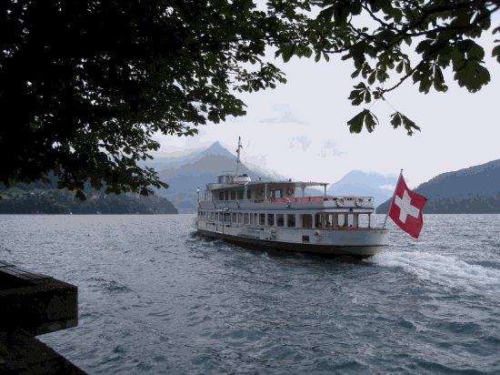
waterfalls crashing down from mountains behind campsite. Sunday 20 June Still raining! Cleared a little pm. Took paddle Steamer to Lucerne. Lovely tour around lake dominated by Mount Pilatus which would be worth a visit on a fine day. Stopped in Lucerne walked around interesting old town with two covered wooden bridges including the 14th Century Chapel Bridge. Text from home they were having a heatwave! |
Tuesday22nd June Not raining. Down the long and winding road again towards Chur and then the N19 towards Italy and hopefully sun. We had the choice of going over the St Bernandino or the Splugen Pass and as the later looked more interesting on our map opted for the Spluga. This was our first Pass not in cloud or mist so it was interesting to pass through the very pretty mountain villages, and see the high mountain pastures covered with wild flowers and grazed by the beautiful herds of cows all with their dangling bells. The road got progressively narrower,steeper and the hairpins tighter, as we approached the top where we were confronted by a border post from Switzerland into Italy. The Italian guards looked somewhat amused to see such a large motorhome passing over the top! On the way down we stopped for a coffee by a beautiful lake enjoying the magnificent scenery , blue skies and hot sun. To our amazement amongst the cyclists and bikers a long convoy of vintage tractors passed by having gone over the Pass! We were later to spot them all lined up outside a restaurant , they were from all over Europe.
It was a long descent down from the Spluga and towards the bottom the brakes on the van suddenly went soft, so it was with some relief that we found a convenient aire in Chiavenna where we could stop to let everything cool down. Soon all was ok and we carried on to Lake Como and the small town of Colico where we planned to stay on the aire. Following the usual Motorhome Aire sign we found ourselves in a carpark with lots of other motorhomes adjacent to the lake. We paid our dues in the machine 6.50euros for 24 hours. We could see no sign of the facilities as advertised in our book. The other vans were all fairly new and the people all seemed to know each other. They also had very smart cars and were all dressed very smartly. We thought they were part of some rally. In the evening we decided to take a stroll along the lakeside as it was cooler for Midge. It was very pleasant with families having evening picnics and windsurfers and sailing on the lake. A little while along the lake we suddenly came upon a restaurant/watersports centre with lots of vans parked up. We went to investigate. This was the aire! It had all the facilities, so where were we and who were all the others vans? We later were informed by a Swiss couple that the other vans in the carpark were a group of Travellers! So we spent one night with the gipsies (as we had paid) and then moved on to the proper aire the next day! A hefty 15euro a night including hookup.
Thursday24th June. After a relaxing day at lake Como we drove on around Como passing through Dongo where Mussolini and his mistress were captured by the Resistance Partisans and hung upside down on lampposts and Menaggio where we stopped for coffee. We had thought of staying here at the Europa Campsite but it looked very crowded and busy so pressed on. Next stop was on Lake Lugano for lunch. The roads here are very twisty, busy and narrow hugging the edge of the lake. Lake Como was much more open, Lake Lugano more Fjord like. We carried on to Lake Maggiore finding an aire at Cannobio on a river near the centre of the medieval old town. 15euro no hookup! but still cheaper than a campsite. Walked around the old town in the evening and felt we had stepped back in time. Untouristy and mostly unchanged. Well worth a visit.
Friday 25th June. Left Cannobio and drove around Lake Maggiore to Baveno and Camping Parisi (28euro incl hookup) situated right on the shores of the lake. Stayed here for 3 nights catching up on chores and just relaxing. We did visit the beautiful Isola Bella taking a boat from Stressa to make the short crossing first to Isle Madre which was a bit touristy and very busy and then to Isola Bella.
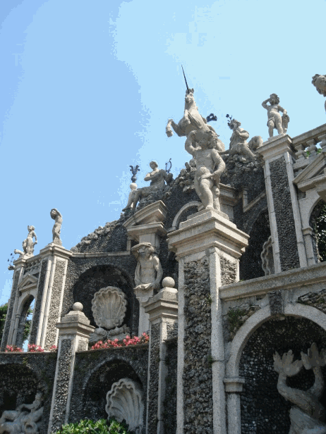
| The island was home to the wealthy Borromeo family who had a palace built on the small island. Within the majestic mansion the Throne and Queens Hall are particularly beautiful and in the Gallery famous paintings including works by Leonardo are displayed. Outside, the Italian Garden, deemed to be the most beautiful in Italy, stands in a coherent pyramidal culminating in a large unicorn statue towering over the lake. White peacocks strut amongst the ten terraces embellished by fountains and statues. Baveno is linked to Stressa by a beautiful road that hugs the lake shore sprinkled with villas of the wealthy and very grand expensive Hotels. There are designer shops, galleries and good restaurants. |
Monday 28th June Reluctantly we leave beautiful lake Maggiore to return to Switzerland. We drive over the Simplon Pass in brilliant sunshine and take the mountain road to Zermatt. At Täsch this is as far as we can go by car and we book into Camping Alphubel a picturesque site adjacent to the railway line which is the only means of getting to Zermatt apart from an hour's hike by foot. That evening whilst sitting outside the van enjoying a G&T and marvelling at the distant views of the Matterhorn and Klein Matterhorn we were approached by a young man from a large bell tent asking us if we would like some homemade pea and ham soup. He explained that he was the nominated cook for the day and had prepared too much for himself and three friends. It was delicious!
Tuesday 29th June We made an early start for our trip up the Klein Matterhorn as we found that in the mountains the weather was at its best early morning with the cloud closing in at about midday onwards. Our first stop was the short walk from the campsite into Täsch to catch the electric train to Zermatt. The station was extremely busy with coach loads of tourists being deposited to board the train to hotels in Zermatt. The cost of this 15min train ride was 21euro p.p. (return)..... which must be the most expensive train ride ever! On arrival at Zermatt we then had to walk through the town – a bit touristy but quite pretty – to the other side to the cable car station. We were a bit apprehensive because having Midge with us we were not sure how she would react to travelling on the cable cars. We need not have worried! She took it all in her stride no problems at all hopping on and off the cars much to the amusement of other passengers. We had been advised by our campsite owner that the Matterhorn Glacier Panorama was the best of the various trips on offer, and we had purchased our tickets through him at a discount price. (No charge for Midge). The first gondola type cable car took us up to Furi at 1867m then a quick change of gondola and off to the next stage which took us up to Troskener Stag at 2939m. Here we got off and had a coffee in the panoramic restaurant. From here there were lots of hikes to go on, all way marked. This area is surrounded by glaciers and high mountain tops unfortunately for us the top of the Matterhorn was already covered in cloud and was to remain like that for the rest of the day apart from a few tantalising glimpses when the cloud lifted. However, all the others were clear against a stunningly clear blue sky so it was truly a wonderful panorama.
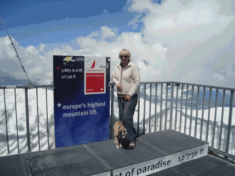 | Our next stage was the big cable car which was to take us up to the top of the Klein Matterhorn. It was quite an ascent getting ever steeper and steeper and as we neared the top becoming completely vertical up the rock face. When we got out the altitude hit us and we were finding it difficult to get our breath. No so Midge she was not bothered at all! Our final ascent was up a lift inside the top of the mountain which brought us out onto the summit at 3883m (12,736ft) the highest lift in Europe. It was breathtaking (literally!) We felt as though we were on top of the world. The Matterhorn was directly behind us but still covered in cloud but elsewhere was crystal clear, the snow was so dazzling white we could not take off our sunglasses it was so bright. |
After a short stop for our picnic lunch spent watching the skiers starting their descent down to Troskener Stag (Midge was kept busy posing for tourists' snapshots) it was time to head back down the mountain. By the time that we got back to the Troskener Stag the weather had suddenly closed in and it had started to rain. It can change so quickly in the mountains. Finally we made it back to Zermatt where the weather improved and we were able to stroll around the town. In the churchyard are the graves and memorials to so many who have lost their lives on the Matterhorn including one to the four climbers who first made the ascent in 1865 but fell and lost their lives on their descent. It was then back to the railway station for the shuttle to Täsch. A great day.
Wednesday 30th June Left Camping Alphubel. Back down to Visp where we rejoined the R9 and enjoyed a very scenic drive through the Rhône Valley, Sion and Martigny. Crossed the border back into France to Les Praz near Chamonix to book in to the Mer de Glace campsite where we had arranged to meet Christine (Pilote friend). Christine was there to greet us and we caught up on all her news . Christine had kindly offered to look after Midge for us for the day so that we could go on the cable car to Mount Blanc. (dogs not allowed).
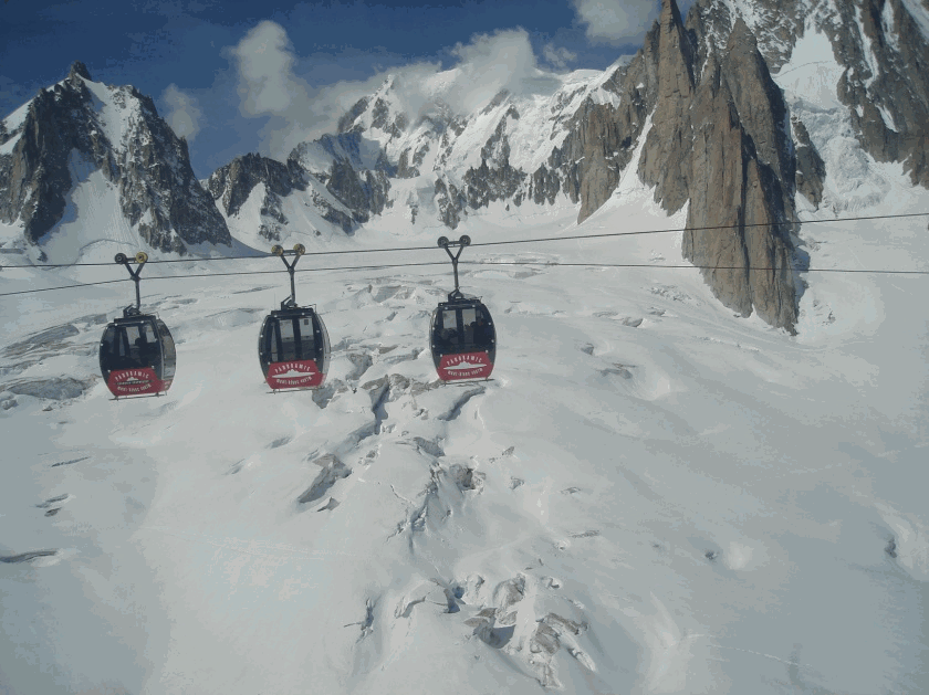 | Thursday 1st July An early start on a lovely clear morning. Caught the 8.30am train into Chamonix and after sorting out our tickets took the cable car to the first stage the Plan de L’Aiguille 7,579ft a hiking departure point. The second section climbs very steeply to the Aiguille du Midi to the Piton Nord at 12,467ft. This is separated from the highest point Piton Central by an abyss spanned by a footbridge. On arriving we crossed the footbridge and took the lift to the Summit Terrace on the Piton Central 12,605ft, where the view stretches through 360º over the entire Alpine chain. The view of the summit of Mont Blanc is amazing and with binoculars possible to watch the steady stream of mountaineers making the slow climb up (and down) the summit. From The Central Tower is the departure point for the Telecabin Aerial ride across the Geant Glacier to Helbronner. |
It was absolutely stunning. Silently gliding in small cabins we seemed to fly over the seracs, and crevasses surrounded by jagged mountain peaks and occasionally stopping at a view point for a magical photo shot. The snow was whiter than white glistening in the bright sunshine. Tiny figures could be spotted traversing the Glacier and climbing the peaks. Amazing. After all this excitement we returned to the North Tower where we found a sunny spot to sit and share our lunch with the many choughs wheeling around looking for a quick snack. There are various terraces with view points, ice tunnels , a restaurant, cafeteria and an exhibition room all at the top! So allow a good few hours to take in all the sites. We returned to the campsite to find that Christine and Midge had had a lovely day together. In the evening we all walked in to Les Praz to the local Hotel and enjoyed a fine meal, sitting outside, with the glorious Mont Blanc as a backdrop.
Friday 2nd July We all travelled into Chamonix to take the Montenvers-Mer De Glace rack and pinion train to see the Mer de Glace Glacier. It takes about 20 minutes to make the climb aboard one of the two remaining rack and pinion mountain trains in France. On arrival we stepped out onto a panoramic terrace at 1913m overlooking the glacier, hard to believe that when the glacier was first discovered it was at a the same height as the terraces! Now there are many steps and a telecabin to take us down to 1600m which is where the glacier has now shrunk to. On our way down there were plaques stating dates when the glacier was at that point. Christine was amazed at how much it had receded since her visit 3 years before. Hewn from the glacier the ice cave enables you to wander around inside the glacier itself and to view the many ice sculptures . On returning to the top we had a picnic lunch on the terrace somewhat spoilt by a group of Scottish students and their very noisy teachers. It was by now very hot so we made our way back to camp to relax. The day ended with a huge thunderstorm.
Saturday 3rd July. Christine leaves today for Italy. We decide to use our passes to go up Le Brevent 8287ft which is on the northern side of the Chamonix valley overlooking the Mont-Blanc range. It is a very popular area for para-gliding and is a departure point for hiking in the Aiguilles Rouges Nature Reserve (no dogs). We really enjoyed this cable car ride to the summit as the 360º views were outstanding. There were very few tourists and no noisy school parties! Planpraz at 2000m is where the paragliders take off from and it was very interesting to sit and watch them soaring high over the valley sometimes it seemed they were higher than Mont-Blanc itself before gently descending to the valley bottom. All too soon it was time for us to return down to collect the van and to continue our journey.
This was the
end of our first part of our Tour.
For the next part of our journey we will be following La Route des
Grandes Alpes
a tourist itinerary through the French Alps between Lake Geneva and the
French
Riviera passing over all the high passes in the French Alps.
To be continued...............
La Route des Grandes Alpes
Part Two of our Tour des Grandes Alpes by Jenny Vowden
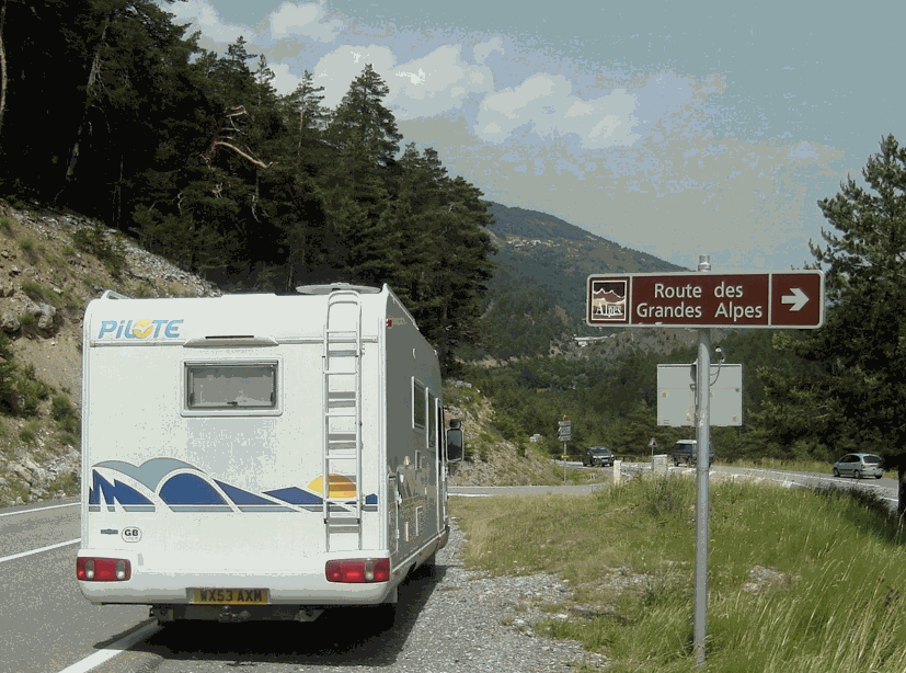 | La Route des Grandes Alpes construction was authorised in 1912 to enable the military to be able to move troops easily from valley to valley. The Touring Club de France whose interests lay in developing routes for its members provided part of the funding. However, The First World War delayed its construction and the route was not completed until 1937 when the Col de L’Iseran was opened. The Col de l’Iseran at 2770m is the highest pass on the route although the highest road in Europe is on the Bonette at 2802m. The Route starts at Thonon-les-Baines on Lake Leman (Geneva) and finishes some 600km later at Menton. We cheated slightly having joined the Route coming from Chamonix to Cluses. |
Sunday 4th July We made a detour off the Route to visit the Memorial and Museum of Resistance at the Cimitiere des Glières which we found to be very moving and interesting. Back on the Route and the road climbs steadily through Alpine pastures to the Col des Aravis and at the pass we found a parking area opposite a farm with a sign "Camping Cars Bienvenue" so decided to stay! It was a gorgeous evening made even more special as our only neighbours were a herd of beautiful Holstein cows! In the morning I walked across to the farm and bought 3 rounds of their Reblochon cheese . It was delicious.
Monday 5th July Our next stop was on the Col des Saisies where there is a big motorhome aire. The Col was the scene of a large weapons drop to the Maquis in August 1944 and is now a touristy ski area. The Route runs on past Beaufort into the Cormet de Roselend, a bleak but beautiful pass, before the descent to Bourge-St-Maurice. We were hoping to stay on an aire at Tignes but it was no longer there. However we found a nice quiet carpark in the little village of Les Boisses.
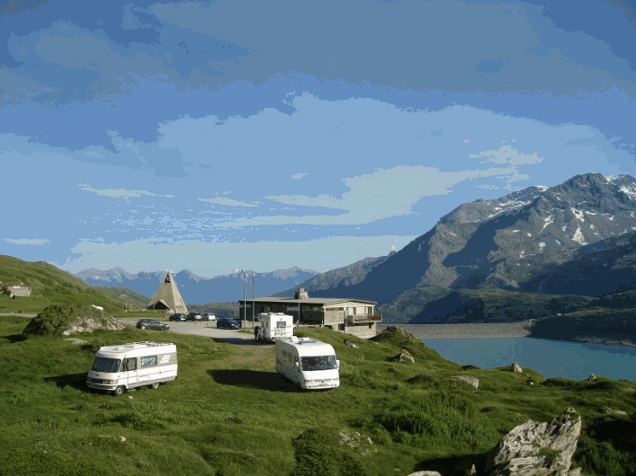
This was built by the Italians to keep the French out but was ceded to France in the 1947 peace treaty. The Col du Mont Cenis pass 6,837ft used to mark the border between France and Italy, which is now a few kilometres further south. There is a dam and large lake with a museum showing the Mont Cenis area before and after the flooding. The whole area is a botanist’s and walker's haven with waymarked routes to glacial lakes, mountain peaks and ruined Napoleonic forts. There is an Alpine Garden and an abundance of wild alpine flowers (even eidelweisse).
 | There were
several motorhomes wild camping
around the lake so we decided to join them and as it was so beautiful
and
peaceful stayed two nights. There are a couple of small restaurants,
toilettes, spring
water and a small shop selling local produce including bread but the
buildings
are presented not to spoil the beauty of the area. Thursday 8th July We awoke to a sea of mist! Which quickly cleared as we made our way back down the mountain to rejoin the Route on the D902. We headed towards St Michel-de-Maurienne, stopping off at the Maria Theresa redoubt on the way. |
This forms part of the Fort de L’Essesillon on the other side of the river and was built in the 1830s by the Duke of Savoy. If you’ve a head for heights, cross the river by foot by the Pont du Diable – we didn’t - just looking at the rope bridge high above the gorge – was enough for us! Modane used to be a sleepy rural area but the construction of the Frejus rail tunnel in 1857-71 changed it into an important rail junction.
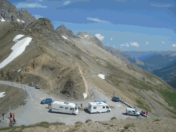 | It was with some trepidation that we approached the next part of La Route as it included the Col du Galibier and there was some concern as to whether our large motorhome would make the notorious hairpins at the top of the climb. So we began the long serpentine haul up first to the Col du Telegraphe 5138ft which has a fort which was not open to the public, a restaurant and a small parking area which was full, so after a quick photo stop decided to carry on. Near Valloire we came across an area with loads of Carthago, Le Voyageur and expensive type motorhomes which was either a very large rally or show. We quickly drove by! |
Friday 9th July After the sheep episode we carried on down to Briançon – the highest town in Europe and after a quick coffee stop by some very inviting lakes (it was very hot) we set off for the Col d’Izoard. The approach from the north twists up through pleasant woodland until it nears the summit just below which is one of the refuges built in 1858 with a legacy from Napoleon. At the summit (7743ft) there is a memorial dedicated to Alpine forces who contributed to the construction of many mountain roads. There is quite a large parking area, a small museum and the usual tacky stalls. It is a 15 minute walk to the viewing platform which afford panoramic views of the area. There’s stark change in scenery as we cross the pass into Casse Déserte, an amazing moonscape of rock pillars, landslips, and scree. A relatively gentle run down took us to Château-Queyras where we booked in to the small Municipal Campsite with welcome shady fir trees to park under and lovely hot showers. 9euros a night, including electricity and showers.
Château Queyras: The village nestles beneath Fort Queyras perched on a rugged knoll which almost completely blocks the entrance to the Guil Valley. This strategic hill at the gateway to the Drance Valley has been fortified since medieval times and was occupied by a garrison until 1967. You could try your hand at mountaineering on a fairly easy via ferrata below the castle. Via ferrata are climbs in accessible places designed for amateurs.
Saturday 10th July The road follows down through the very scenic Gorges des Guilestrel (a bit like the Verdon Gorges) to the Col de Vars (6962ft) which was hot, dry, dusty and very touristic so did not stop. The pass is the gateway to the Ubaye Valley in an arid landscape of meagre pasture. Small hamlets depend on cattle farming and handicrafts. We found a good lunch stop by the fast flowing river gorge and spent a couple of hours watching canoeists tackling the rapids. After lunch we made a detour to Tournoux mountain village to see the forts but it was a 40 min walk and too hot for Midge so gave it a miss.
Until skiing became popular there was nothing in the Ubaye Valley except agriculture and fortifications. The Fort de Tournoux is one of the most impressive in France and would be well worth a visit. The fort was the centrepiece of a series of fortifications designed to keep the Italians out, which they did to good effect in 1940.
We continued on to Jausiers a small town where there was a good large free camping area by the river.
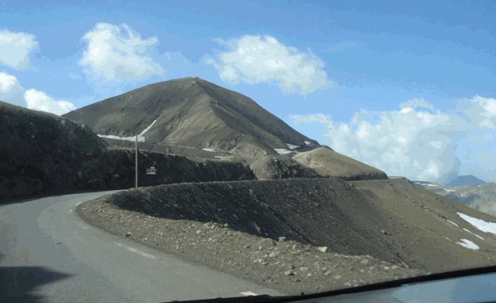 | The top of the mountain is most unusual, more volcanic in shape, the road winds its way around the cone to a small parking area and monument. There was a choice of direction around the summit and we were glad that we had chosen to go clockwise as this enabled us to keep away from the edge! For miles along the top there isn’t much except for fortifications, many of which came in handy when the Italians invaded in 1940. The road’s origins are largely military and it was not opened for public use until about 1960 which is why it wasn’t on the original Grande Route. |
It was a very long hot tiring descent with many hairpins and narrow roads with rocky overhangs so by the time we reached the N202 we were suffering from hairpin fatigue. We had not been able to find anywhere to stay on the descent no suitable campsites, aires, or wild camp spots so it was with some relief that we came across an aire at Puget-Théniers, right by the river so we were all able to have a welcome paddle. Others were brave enough to swim but it was very fast flowing and quite rocky.
We were now back on the Route which follows the N202 (now D6202) for a further 25 miles down to its finish in Nice. However we were to leave it now travelling north to Gap to watch a stage of the Tour de France before heading for home.
Our Tour des Grandes Alpes had finished. We had driven over a total of 22 cols and mountain passes and driven 1,852 miles. We stayed 14 nights in campsites, 8 at aires and 6 wild camping.
We had a further 1,150 miles to travel before we reached home but that’s another story!
text and photos Copyright© 2010 J Vowden
top | Home | Europe campsites | European Touring | UK touring | Disclaimer